A few miles east of Cornudas, Texas, in Hudspeth County on Highway 62 / 180, the Guadalupe Mountains are visible many miles farther in one’s line of sight. Like the wreckage of a great, ocean-going vessel, they rise from the salt plains to ascend to great heights in a dramatic uplift of a mutely grandiose manner that overshadows nearby ranges. Once the remaining traces of the far, far, far eastern edge of El Paso along the highway appear small in the rearview mirror, the windshield reveals unspoiled country. Geologists identify the rolling terrain on either side of the asphalt ribbon as the Hueco Bolson, named for the nearby sacred mountains bearing the first half of that name. Among the dips and rises across the landscape as far as the good eyes can see, the Earth’s crust is folded and compressed and thrusted upward in a frozen testament to the excruciatingly long, violent upheaval geologic time demanded to mold the land according to its wishes. Spanish dagger, creosote, and yucca color the terrain with shades of green and yellow and a bit of white. On either side of the road, the ubiquitous Trans-Pecos three-strand bobwar fence runs parallel to remind passersby to literally stay in their lane and not test the fence. Long-stem grasses blanket the rolling terrain, and in between, the asphalt-covered road wends across this delightfully remote corner of Texas.

But for two green signs with white letters some short space apart saying otherwise, hardly a soul would be aware of the existence of Cornudas, Texas; the distance between the east side and west of town being measured in eye blinks, after all. “Town” is a highly generous appellation to describe Cornudas, as it is more a spirit of place that derives its name from the eponymous geologic protrusion well to the north, but within one’s viewshed, near the New Mexico line. The Cornudas Mountains also lent their name to a nearby station on the Butterfield Overland Mail route near the base of Los Cornudas, as the mountains are identified on Samuel Augustus Mitchell’s 1859 Map of Texas. When eastbound travelers in recent times zoom by en route for the Guadalupe Mountains National Park, the Cornudas Mountains often appear as just another stony pimple on the earth’s surface way off in the distance. But on this particular day—May 24, 2020, to be exact—the two of us had embarked on an extensive Sunday drive, encompassing a big loop from Las Cruces down to El Paso, over to Cornudas and then south to Sierra Blanca, followed by a westward drive to the Pass of the North, before returning home to Doña Ana County. We drove well more than two hundred miles all told just to see an ancient corner of Arid America—and we enjoyed every minute of it.
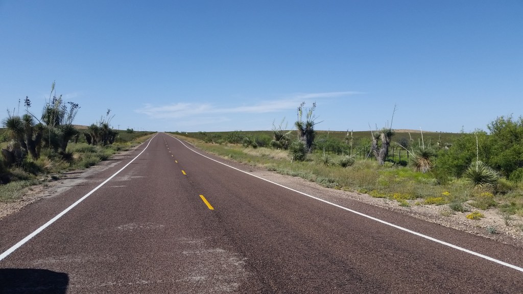

And then with the café in Cornudas long in our rearview mirror, we arrived at the T-intersection of the United States highway and the Texas farm to market road, the route designated as Texas FM 1111. For some forty miles, this road runs along a north-south axis with hardly a curve in it until it zigs and zags on the north side of Sierra Blanca. Within those short forty miles or so, we drove at a leisurely pace and stopped a couple of times to have a still-life look at the landscape. May in the Chihuahuan Desert shares its dry heat indiscriminately among birds, beasts, and flowers, and the temperature differential between the cool comfort inside the Pathfinder and the ceaseless bone-warming heat pressing down on the land offer stark contrasts. “So it goes,” sayeth Linda Ellerbee. We drove a bit. Upon stopping for a few minutes to have a look around and snap a photo or two, I regarded the land’s geology with keen interest. Recently, I’ve cast an attentive eye toward this region’s rugged beauty and have begun to attempt to place myself in the sturdy boots of those intrepid geologist-explorers whose surveys of this land reach back into the latter decades of the Nineteenth Century. Far be it for me to assume that the three credit hours I amassed in geology at Texas Tech are sufficient to achieve a deep understanding, but rather when I read the words of those who looked at this land through the geological prism of their profession, I appreciate more my views of the land. That is to say, the landforms I am looking at have meaning beyond what may be gleaned through a casual sweep of the eyes across the desert floor. We drove on. Up ahead, we could see a faint but discernable black line stretching perpendicular in our lane, and as we approached, it moved snappily toward the road’s edge. That Western Diamondback undoubtedly was none too pleased that our tires disrupted his sunbath on that warm asphalt, but in hindsight I hope Mr. Snake eventually recognized that ducking for cover was a helluva lot preferable than finding himself beneath a set of Michelins.…


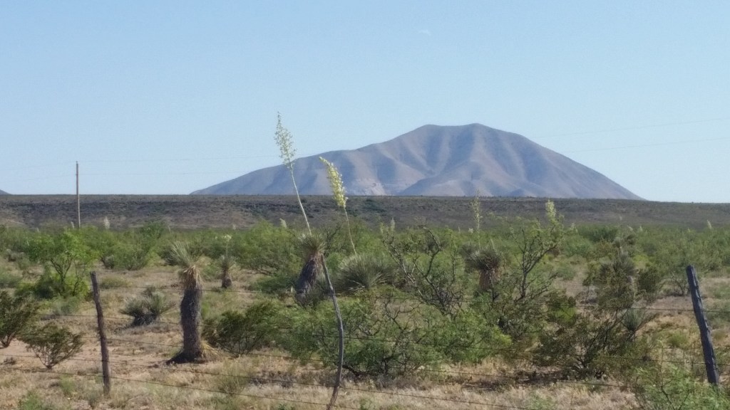
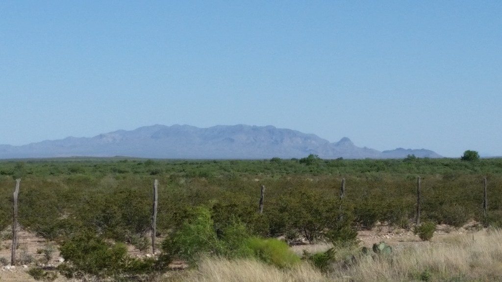
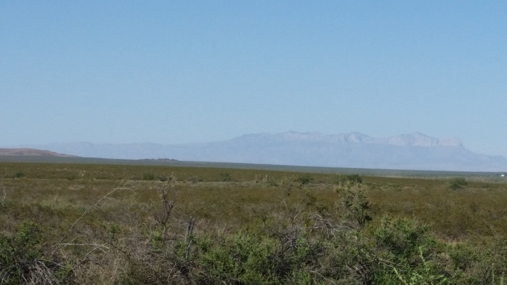
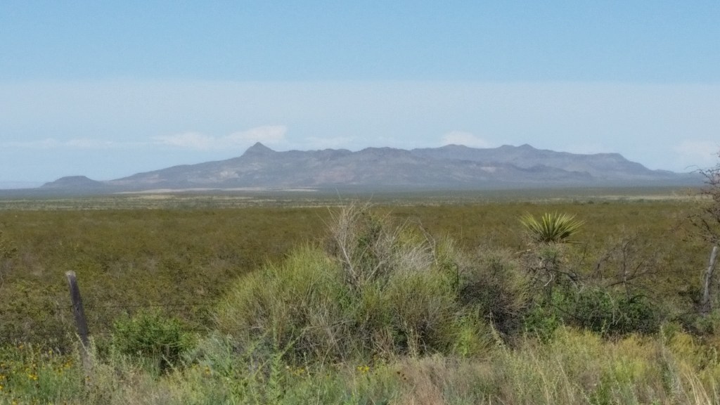
A few more miles down the road, my focus was drawn to a cluster of uplifts to the southwest, and what was particularly intriguing was the vantage point from which we were looking at them. Granted, we’d seen them plenty of times before, but on those occasions we were looking at their features through the windows while driving along Interstate 10, and besides, we were looking at their southern faces; on FM 1111, we could see their north sides. Along this stretch of road, the land dips and falls like crests of slowing rolling waves making landfall on South Padre Island, and at one point I asked Christina to slow down a bit so we could pull over where the view was good. And then like a scene out of Mutual of Omaha’s Wild Kingdom, not only did that farm to market road bend sharply to the left, but from the brush off the right shoulder emerged a long-legged antelope who must have reckoned that this spot at this very moment offered the ideal conditions to cross to the other side. Had the road been arrow straight, had Christina not needed to brake to slow accordingly, and had that antelope made tracks more slowly, a calamity might have occurred. But it was not to be. That indifferent antelope jumped the bobwar fence line on the left side of the road and wandered into the tall grass among the mesquites. A little further on, we stopped so I could snap some shots of Sierra Blanca Peak and its neighbors, Little Blanca Mountain, Triple Hill, Round Top, and Little Round Top. While we had seen them many times before, we were looking at them from this view for the first time, and they were worth beholding.
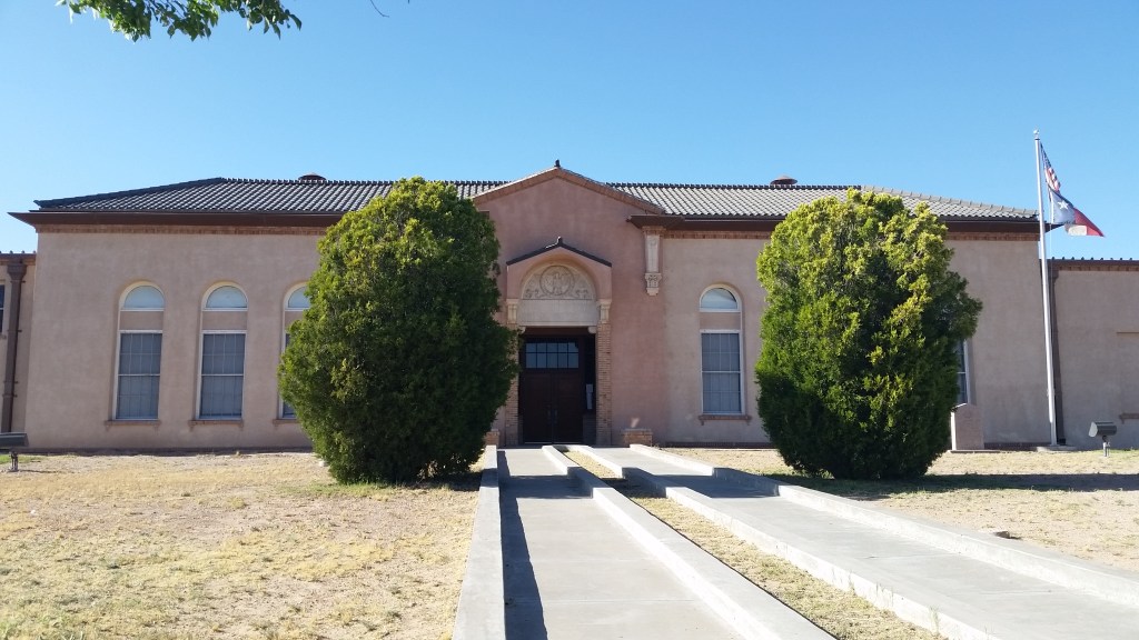
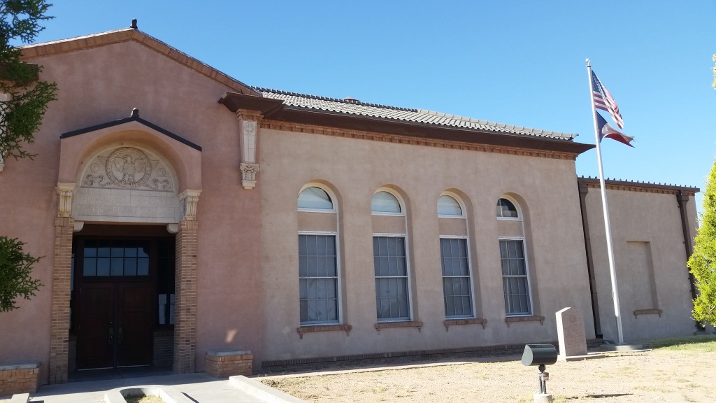
We drove on for the remaining ten miles or so to Sierra Blanca, the capital city of Hudspeth County, as I’ve mentioned elsewhere. Somewhere north of five hundred people call Sierra Blanca home, and it is the county’s most populated spot. All things are relative, I suppose. Sierra Blanca’s current population far exceeds the number of my graduating high school class in 1989, but then again, if they consisted of the entirety of a Friday night crowd at Hawk Stadium, our guys on the football field would have been mightily disappointed by such a small turnout. But there we were on this Sunday afternoon, far removed from Northeast Texas and in the minds of many, a million miles from nowhere. But there was one thing I needed to do while in town, and that was to have a look at a building. On this particular occasion, that specific building was the county courthouse. When we pulled up before it, I could tell it was distinctive in its own right, and that notion was reinforced upon closer inspection. The front elevation, on a musical scale, is a simple A:B:C:B:A rhythm (not quite “Abacab” by Genesis, but bear with me) (and therein lies a whole different story) (to be told later if I remember to do so) that suggests an awareness of classical design and proportion as embraced in Greece and Rome. In its graceful simplicity, the Hudspeth County Courthouse intrigues me; I am of a mind to consider it one of the truly distinctive public buildings anywhere in Texas. And there we were, standing before it, looking at it, talking about it, trying to make some sense of it all in the big picture of architecture. Alas, we pulled away, and a few moments later we found ourselves on the interstate highway driving fast and making tracks to El Paso. The rest of the trip was consumed by conversation and observation.

Later that night back home when it was quiet, the unstable and unpredictable musical Rolodex in my head dredged up “Alice’s Restaurant” for reasons I can’t explain. Maybe Arlo’s refrain surfaced from the recesses of my mind, maybe I was thinking of something my dad once told me, maybe I was just making nonsensical connections, quien sabe? Even if I can’t explain that angle, my mind’s eye was filled with sharp, indelible images of a beautiful land seen only hours before. That Christina and I saw it together only made the memory more meaningful. Not a bad way to spend a day, eh?

Any quote of Linda Ellerbe makes me a fan. Thanks from Roberta
LikeLiked by 1 person
Just couldn’t resist showing your Tech pride!
Thanks for sharing the unique beauty of this land.
LikeLiked by 1 person
You have a way of making it as though I’m there. Thanks Troy! Love the pics.
LikeLiked by 1 person
Thanks for sharing this story. My wife’s family has deep ties to Sierra Blanca and Hudspeth County. Her great-great grandmother came to the Cornudas Mountains in a covered wagon and lived to the ripe age of 107! You may enjoy reading about her here: https://www.findagrave.com/memorial/76448685/mary-lucretia-neely
-Greg L
LikeLiked by 1 person